
جانیا:Fulton County Georgia Incorporated and Unincorporated areas Atlanta Highlighted.svg

حجم پیشنمایش PNG این SVG file:۶۷۵ × ۶۰۰ پیکسل هنیگۉپ نما کردنؽا: ۲۷۰ × ۲۴۰ پیکسل | ۵۴۰ × ۴۸۰ پیکسل | ۸۶۴ × ۷۶۸ پیکسل | ۱٬۱۵۲ × ۱٬۰۲۴ پیکسل | ۲٬۳۰۴ × ۲٬۰۴۸ پیکسل | ۹۰۰ × ۸۰۰ پیکسل.
جانؽا ٱسلی (جانؽا اْس ڤی جی, نومی ۹۰۰ × ۸۰۰ پیکسل, ٱندازٱ جانؽا: ۲۷۷ کیلوبایت)
| تۉزی |
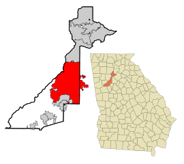
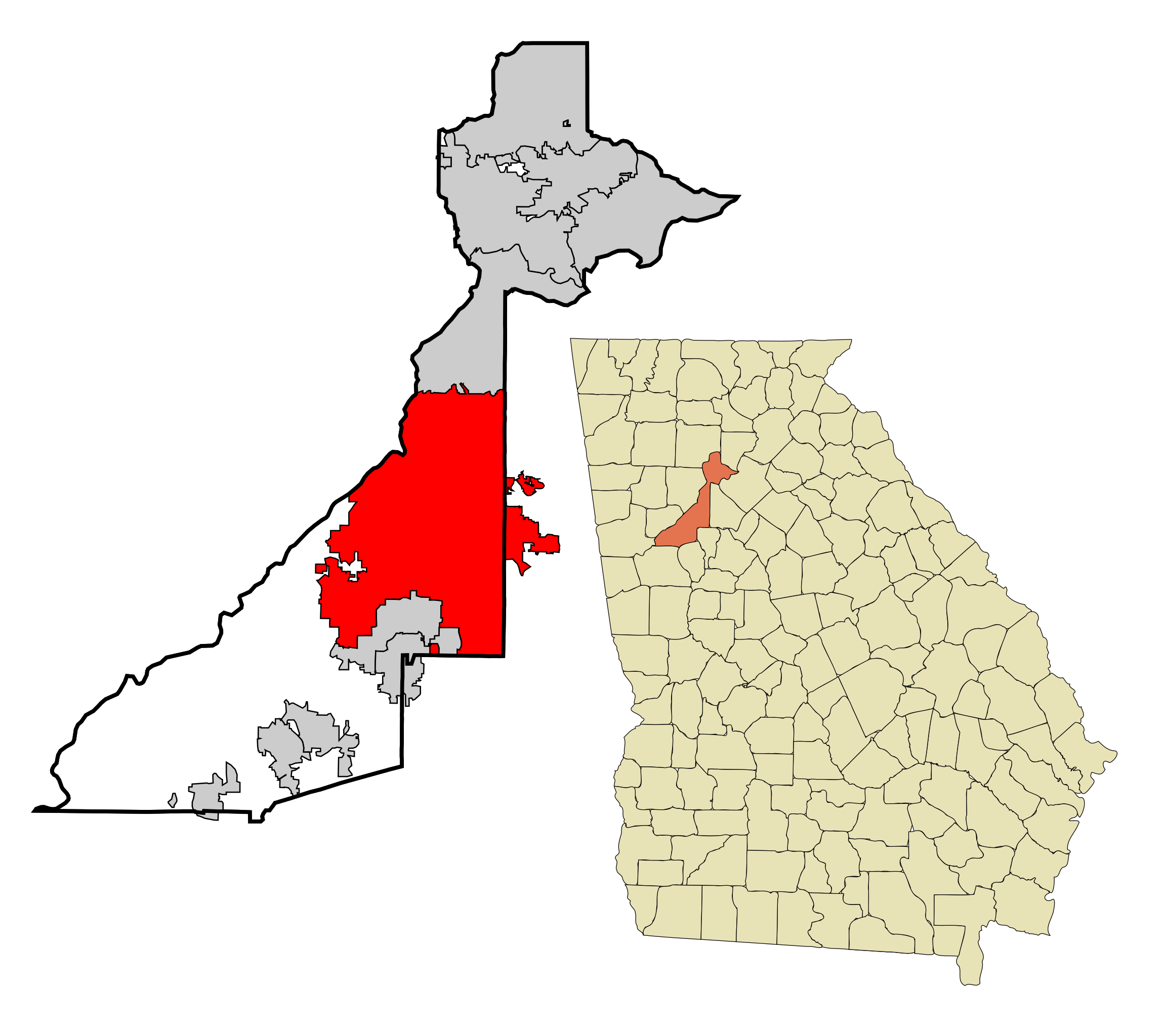
This map shows the incorporated and unincorporated areas in Fulton County, Georgia. Atlanta is highlighted in red.
|
| گات | |
| سرچشمٱ | My own work, based on public domain information. Based on similar map concepts by Ixnayonthetimmay |
| نڤیسیار | Arkyan |
من، صاحب حقوق قانونی این اثر، به این وسیله این اثر را تحث اجازهنامههای ذیل منتشر میکنم:

|
اْجازٱڤرداشتن، درتیچ کاری ۉ/یا آلشت داٛئن سی سنٱد زؽر نخیز شٱرایت موجٱڤز موستٱنٱدؽا آزاد گنو، نۏسخٱ ۱٫۲ یا هٱر نۏسخٱ نهایی کاْ ڤ دٱس بونیاد نٱرم ٱفزار آزاد درتیچ کار بیٱ; بؽ بیئن بٱئرجایا ایستا (بؽ آلشت)، نیسسٱیا ری جلد، ۉ نیسسٱیا دما جلد، ڤ تو داٛئٱ مۊئٱ. یاٛ ڤرداشت د موجٱڤز د یاٛ بٱئرجا ڤا داسوݩ موجٱڤز موستٱنٱدؽا آزاد گنو دما دیس کاری بیٱ. |
| اؽ جانؽا زؽرنٱخیز لیسانس Creative Commons Attribution-Share Alike 3.0 Unported ٱ . | ||
| ||
| این برچسب مجوز بهعنوان بخشی از روزآمدسازی مجوز GFDL، به این پرونده افزوده شد. |
این پرونده با اجازهنامهٔ کریتیو کامانز Attribution-Share Alike 2.5 عمومی، 2.0 عمومی و 1.0 عمومی منتشر شده است.
- شما آزادؽت:
- سی بٱئرکنوݩ – سی ڤرداشتن، درتیچ کردن ۉ داٛین سی کار
- د نۊ د یٱک شؽڤسن – سی هومدٱنڳی ڤا کار
- زؽر نخیز شٱرتؽا هاری:
- کاریاری کردن – شما بایٱد آرنڳ ناْ جۊرؽ کاْ ڤ دٱس نڤیسکاریا موجٱڤز دٱ موشٱخٱس بیٱ، نسبٱت کاری بٱکؽت(ڤلی نٱ جۊرؽ کاْ ڤانمۊد بۊئٱ کاْ ڤنو شما یا ڤ کار گرتن شما ناْ د آرنڳ پر ۉ پیم کاری کردنٱ).
- بٱئرکنوݩ چی – ٱر شما اؽ کار ناْ ٱنجوم باٛئؽت یا آلشتش بٱکؽت یا ڤٱناْ جا ڤ جا بٱکؽت شایٱت یٱ باعس بۊئٱ کاْ نٱتیجٱ کار شما زؽر نخیز یاٛ لیسانس هنی یا چی دماییا درتیچ با.
شما سی اؽ گوزنیشتو باس یاٛ لیسانس اْنتخاب بٱکؽت.
ڤیرگار جانؽا
ری ڤيرگارؽا بٱپۊرنؽت تا نۏسخٱ مٱربۊتاْ باٛینؽت.
| ڤيرگار/ڤٱخت | عٱسگ کوچک بیٱ | اۊیٱکؽا | کاریار | ڤیر ۉ باڤٱر | |
|---|---|---|---|---|---|
| تازٱ با | ۱۲ مارس ۲۰۱۸، ساعت ۱۱:۴۸ | | ۹۰۰ در ۸۰۰ (۲۷۷ کیلوبایت) | Haha169 | Add a few more parcels, fix the boundaries of the Emory annexation to include the Dekalb fire station carve out |
| ۲ ژانڤیٱ ۲۰۱۸، ساعت ۰۹:۵۹ |  | ۹۰۰ در ۸۰۰ (۲۷۶ کیلوبایت) | Haha169 | fix | |
| ۲ ژانڤیٱ ۲۰۱۸، ساعت ۰۳:۱۲ |  | ۹۰۰ در ۸۰۰ (۲۷۶ کیلوبایت) | Haha169 | updated with new borders since 2007 | |
| ۲۶ اوکتوبر ۲۰۰۷، ساعت ۱۴:۵۷ |  | ۹۰۰ در ۸۰۰ (۲۷۹ کیلوبایت) | ArkyBot~commonswiki | {{Information |Description=This map shows the incorporated and unincorporated areas in Fulton County, Georgia, highlighting Atlanta in red. It was created wit | |
| ۱۹ سپتامر ۲۰۰۷، ساعت ۲۰:۵۶ |  | ۹۰۰ در ۸۰۰ (۲۵۹ کیلوبایت) | ArkyBot~commonswiki | {{Information |Description=This map shows the incorporated and unincorporated areas in Fulton County, Georgia, highlighting Atlanta in red. It was created wit |
ڤ کار گرتن جانؽا
ایچاْ هیچ بٱلگاٛیی سی هوم پیاٛڤٱن بیئن ڤا اؽ جانؽا نؽ