
جانیا:Tripura map.png
ٱندازٱ اؽ پیش ساٛلٛ:۴۱۳ × ۵۹۹ پیکسل. هنیگۉپ نما کردنؽا: ۱۶۵ × ۲۴۰ پیکسل | ۳۳۱ × ۴۸۰ پیکسل | ۸۹۹ × ۱٬۳۰۴ پیکسل.
جانؽا ٱسلی (۸۹۹ × ۱٬۳۰۴ پیکسل, ٱندازٱ فایلٛ: ۱۶۴ کیلوبایت, MIME نوع: image/png)

|
این locator map نگاره میبایست با استفاده از گرافیک برداری اسویجی فایل بازسازی شوند. این چند مزیت دارد؛ Commons:Media for cleanup را برای اطلاعات بیشتر ببینید. اگر حالت برداری آن در حال حاضر موجود است، لطفاً آن را بار کنید. پس از بارکردن یک اسویجی، این الگو را با {{vector version available|new image name.svg}} جایگزین کنید.
|
چکسٱ
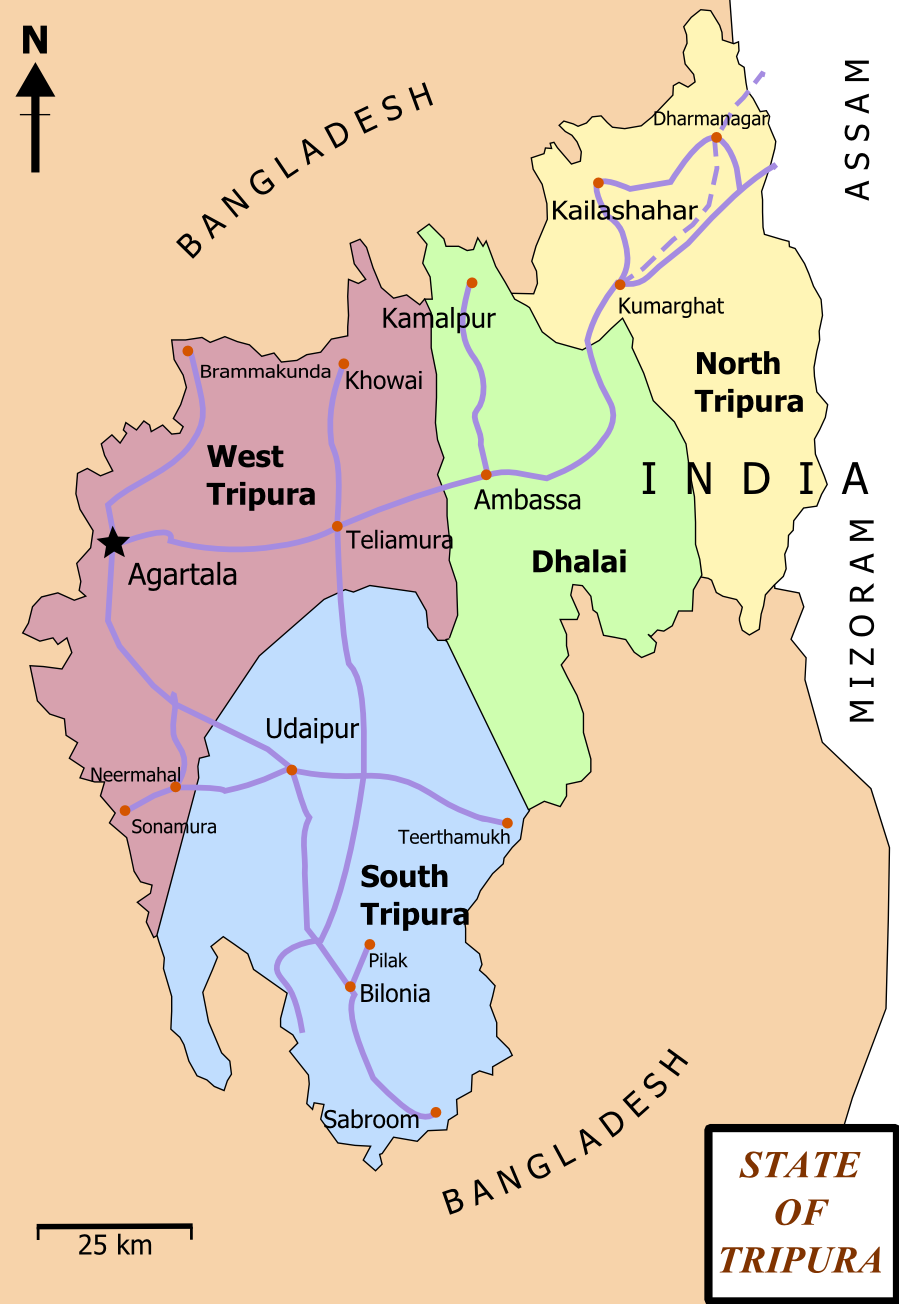
| تۉزی | Map of State of Tripura. The map shows the former 4 districts of Tripura, with the state's roads and railway networks detailed. Railway was extended upto Agartala from Kumbarghat and opened by 2008.[1] |
| گات | |
| سرچشمٱ | کار خود |
| نڤیسیار | Wikigringo |
| دٱسرسی (د نۊ ڤ کار گرتن اؽ جانؽا) |
attribution to author. |
| دیگر نسخهها | Tripura locator map blank.svg.png |
| عنوان مقاله |
Tripura locator map |
| Description |
Locator map of the state of Tripura, India with district boundaries. |
| گات | |
| سرچشمٱ |
کار خود |
| پدیدآورنده | |
| دٱسرسی (د نۊ ڤ کار گرتن اؽ جانؽا) |
من، صاحب حقوق قانونی این اثر، به این وسیله این اثر را تحث اجازهنامهٔ ذیل منتشر میکنم: اؽ جانؽا زؽرنٱخیز لیسانس Creative Commons Attribution-Share Alike 3.0 Unported ٱ .
|
| Geotemporal data | |
| Date depicted | نیمهٔ دوم سدهٔ 20 و سدهٔ 21 |
| Georeferencing | If inappropriate please set warp_status = skip to hide. |
| Archival data | |
| یادداشتها | Part of WikiProject India Maps |
د هال ۉ بار لیسانس دار بیئن
من، صاحب حقوق قانونی این اثر، به این وسیله این اثر را تحث اجازهنامههای ذیل منتشر میکنم:

|
اْجازٱڤرداشتن، درتیچ کاری ۉ/یا آلشت داٛئن سی سنٱد زؽر نخیز شٱرایت موجٱڤز موستٱنٱدؽا آزاد گنو، نۏسخٱ ۱٫۲ یا هٱر نۏسخٱ نهایی کاْ ڤ دٱس بونیاد نٱرم ٱفزار آزاد درتیچ کار بیٱ; بؽ بیئن بٱئرجایا ایستا (بؽ آلشت)، نیسسٱیا ری جلد، ۉ نیسسٱیا دما جلد، ڤ تو داٛئٱ مۊئٱ. یاٛ ڤرداشت د موجٱڤز د یاٛ بٱئرجا ڤا داسوݩ موجٱڤز موستٱنٱدؽا آزاد گنو دما دیس کاری بیٱ. |
This file is licensed under the Creative Commons Attribution-Share Alike 4.0 International, 3.0 Unported, 2.5 Generic, 2.0 Generic and 1.0 Generic license.
- شما آزادؽت:
- سی بٱئرکنوݩ – سی ڤرداشتن، درتیچ کردن ۉ داٛین سی کار
- د نۊ د یٱک شؽڤسن – سی هومدٱنڳی ڤا کار
- زؽر نخیز شٱرتؽا هاری:
- کاریاری کردن – شما بایٱد آرنڳ ناْ جۊرؽ کاْ ڤ دٱس نڤیسکاریا موجٱڤز دٱ موشٱخٱس بیٱ، نسبٱت کاری بٱکؽت(ڤلی نٱ جۊرؽ کاْ ڤانمۊد بۊئٱ کاْ ڤنو شما یا ڤ کار گرتن شما ناْ د آرنڳ پر ۉ پیم کاری کردنٱ).
- بٱئرکنوݩ چی – ٱر شما اؽ کار ناْ ٱنجوم باٛئؽت یا آلشتش بٱکؽت یا ڤٱناْ جا ڤ جا بٱکؽت شایٱت یٱ باعس بۊئٱ کاْ نٱتیجٱ کار شما زؽر نخیز یاٛ لیسانس هنی یا چی دماییا درتیچ با.
شما سی اؽ گوزنیشتو باس یاٛ لیسانس اْنتخاب بٱکؽت.
ڤیرگار جانؽا
ری ڤيرگارؽا بٱپۊرنؽت تا نۏسخٱ مٱربۊتاْ باٛینؽت.
| ڤيرگار/ڤٱخت | عٱسگ کوچک بیٱ | اۊیٱکؽا | کاریار | ڤیر ۉ باڤٱر | |
|---|---|---|---|---|---|
| تازٱ با | ۱۵ فڤریٱ ۲۰۱۲، ساعت ۱۷:۰۶ | | ۸۹۹ در ۱٬۳۰۴ (۱۶۴ کیلوبایت) | Ras67 | cropped and optimized |
| ۲۷ فڤریٱ ۲۰۰۸، ساعت ۱۳:۱۵ |  | ۹۲۱ در ۱٬۳۲۶ (۲۲۹ کیلوبایت) | Wikigringo | {{Information |Description=Map of State of Tripura. Map shows the 4 districts of Tripura along with roadways and small railway network present in the state. |Source=self-made |Date=02/27/2008 |Author= Wikigringo |Permission=attribution |
ڤ کار گرتن جانؽا
ایچاْ هیچ بٱلگاٛیی سی هوم پیاٛڤٱن بیئن ڤا اؽ جانؽا نؽ