جانیا:Washington, D.C. locator map.svg
Page contents not supported in other languages.
د ڤیکیپدیا، دونسمنامٱ آزاد

جانؽا ٱسلی(جانؽا اْس ڤی جی, نومی ۷۵۰ × ۵۵۰ پیکسل, ٱندازٱ جانؽا: ۱۶۰ کیلوبایت)

فایلٛؽ کاْ د ویکی‌انبار شایٱد د مؽن پرۉژٱیا هنی اْستفادٱ بیٱ. تۉزیی دبارٱfile description page د هار نشوݩ داٛئٱ بیٱ

تۉزی
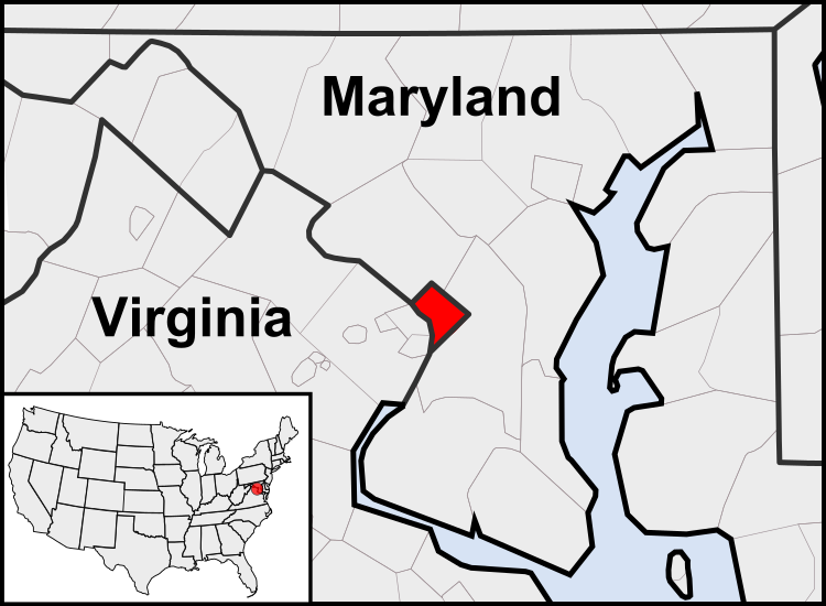
English: This is a map of the location of the District of Columbia showing the borders of states and counties around it.
گات (UTC)
سرچشمٱ
نڤیسیار
دیگر نسخه‌ها

Derivative works of this file:  United States geographical collation.svg All the below are of the states (and DC) only.
Blank US map.svg Map of states
Labelled US map.svg Map with state labels
USA_blank.svg Image with Hawaii and Alaska in full size
Original blank map of USA and Canada, That image with labels
Original with Hawaii at the natural distance, That original map with labels

File:DC locator map with state names w usmap.png and File:DC locator map with state names.jpg


این یک عکس دستکاری شده است به این معنی که به صورت دیجیتالی از نسخهٔ اصلی تغییر یافته‌است. تغییرها: Cropping to area around District of Columbia. اصل آن را می‌توان در اینجا مشاهده کرد: Blank USA, w territories.svg. تغییرها توسط Patrickneil انجام شده‌است.

w:fa:کرییتیو کامنز
کاریاری کردن بٱئرکنوݩ چی
اؽ جانؽا زؽرنٱخیز لیسانس Creative Commons Attribution-Share Alike 3.0 Unported ٱ .
شما آزادؽت:
  • سی بٱئرکنوݩ – سی ڤرداشتن، درتیچ کردن ۉ داٛین سی کار
  • د نۊ د یٱک شؽڤسن – سی هومدٱنڳی ڤا کار
زؽر نخیز شٱرتؽا هاری:
  • کاریاری کردن – شما بایٱد آرنڳ ناْ جۊرؽ کاْ ڤ دٱس نڤیسکاریا موجٱڤز دٱ موشٱخٱس بیٱ، نسبٱت کاری بٱکؽت(ڤلی نٱ جۊرؽ کاْ ڤانمۊد بۊئٱ کاْ ڤنو شما یا ڤ کار گرتن شما ناْ د آرنڳ پر ۉ پیم کاری کردنٱ).
  • بٱئرکنوݩ چی – ٱر شما اؽ کار ناْ ٱنجوم باٛئؽت یا آلشتش بٱکؽت یا ڤٱناْ جا ڤ جا بٱکؽت شایٱت یٱ باعس بۊئٱ کاْ نٱتیجٱ کار شما زؽر نخیز یاٛ لیسانس هنی یا چی دماییا درتیچ با.

پهرستنومه سوارکرد اصلی

This image is a derivative work of the following images:

  • File:USA_Counties.svg licensed with PD-USGov-DOC-Census
    • 2007-12-23T15:47:48Z Lokal Profil 555x352 (2124572 Bytes) Fixed state borders and fixed the two parts of Fulton County (Kentucky)
    • 2007-12-10T02:20:23Z Lokal Profil 555x352 (2136501 Bytes) Graphical and code cleanup
    • 2007-12-10T01:15:05Z Lokal Profil 792x612 (2135690 Bytes) First stab at a code cleanup
    • 2006-08-29T00:14:37Z Petr Dlouhý 792x612 (2844548 Bytes) Original file: [[:en:Image:USA CountiesSVG.zip]] This [[ZIP (file format)|ZIP]] file contains an [[SVG]] map of the [[United States]] showing the borders of states and counties in high detail. It was derived from [http://ww
  • File:Blank_USA,_w_territories.svg licensed with Cc-by-sa-3.0-migrated, GFDL
    • 2009-01-30T01:59:59Z Hoshie 959x593 (98189 Bytes) Reverted to version as of 23:58, 14 January 2009 - rv myself; DC can be seen clearly.
    • 2009-01-18T23:34:42Z Hoshie 959x593 (102341 Bytes) Put DC in an inset; fixed Tutuila (American Samoa)
    • 2009-01-14T23:58:05Z Lokal Profil 959x593 (98189 Bytes) Code cleanup and removed stroke from Guam and American Samoa
    • 2009-01-13T05:19:51Z Hoshie 959x593 (101361 Bytes) re did Guam and added American Samoa
    • 2007-12-02T16:08:45Z Lokal Profil 959x593 (88960 Bytes) {{Information |Description=A blank map of the United States including Puerto Rico, Guam, the United States Virgin Islands, and the Northern Mariana Islands. |Source=This version was made by [[:User:Lokal_Profil|Lokal_Profil]]

Uploaded with derivativeFX

عنوان

شرحی یک‌خطی از محتوای این فایل اضافه کنید

آیتم‌هایی که در این پرونده نمایش داده شده‌اند

توصیف‌ها فارسی

۱۲ آگوست 2010

ڤیرگار جانؽا

ری ڤيرگارؽا بٱپۊرنؽت تا نۏسخٱ مٱربۊتاْ باٛینؽت.

(ایسنی تریݩ | قاٛیمی تریݩ) ديئن (ڤانوئاتر 1ڤانوئاتر ۱۰ | ) (۱۰ | ۲۰ | ۵۰ | ۱۰۰ | ۲۵۰ | ۵۰۰)
ڤيرگار/ڤٱختعٱسگ کوچک بیٱاۊیٱکؽاکاریارڤیر ۉ باڤٱر
تازٱ با‏۲۳ جۊلای ۲۰۱۱، ساعت ۰۳:۲۳كوچک کردن سی نۏسخٱ چی ‏۲۳ جۊلای ۲۰۱۱، ساعت ۰۳:۲۳۷۵۰ در ۵۵۰ (۱۶۰ کیلوبایت)PatrickneilReverted to version as of 03:04, 23 July 2011
‏۲۳ جۊلای ۲۰۱۱، ساعت ۰۳:۲۱كوچک کردن سی نۏسخٱ چی ‏۲۳ جۊلای ۲۰۱۱، ساعت ۰۳:۲۱۷۵۰ در ۵۵۰ (۱۶۱ کیلوبایت)PatrickneilReverted to version as of 03:14, 23 July 2011
‏۲۳ جۊلای ۲۰۱۱، ساعت ۰۳:۲۰كوچک کردن سی نۏسخٱ چی ‏۲۳ جۊلای ۲۰۱۱، ساعت ۰۳:۲۰۷۵۰ در ۵۵۰ (۱۶۱ کیلوبایت)Patrickneilframe
‏۲۳ جۊلای ۲۰۱۱، ساعت ۰۳:۱۴كوچک کردن سی نۏسخٱ چی ‏۲۳ جۊلای ۲۰۱۱، ساعت ۰۳:۱۴۷۵۰ در ۵۵۰ (۱۶۱ کیلوبایت)Patrickneilthicker frame
‏۲۳ جۊلای ۲۰۱۱، ساعت ۰۳:۰۴كوچک کردن سی نۏسخٱ چی ‏۲۳ جۊلای ۲۰۱۱، ساعت ۰۳:۰۴۷۵۰ در ۵۵۰ (۱۶۰ کیلوبایت)Patrickneilstraightening Maryland and Delaware borders
‏۱۵ آگوست ۲۰۱۰، ساعت ۰۲:۰۹كوچک کردن سی نۏسخٱ چی ‏۱۵ آگوست ۲۰۱۰، ساعت ۰۲:۰۹۷۵۰ در ۵۵۰ (۲۰۲ کیلوبایت)PatrickneilDelaware River again
‏۱۵ آگوست ۲۰۱۰، ساعت ۰۱:۵۱كوچک کردن سی نۏسخٱ چی ‏۱۵ آگوست ۲۰۱۰، ساعت ۰۱:۵۱۷۵۰ در ۵۵۰ (۲۷۴ کیلوبایت)PatrickneilDelaware River border
‏۱۵ آگوست ۲۰۱۰، ساعت ۰۱:۴۲كوچک کردن سی نۏسخٱ چی ‏۱۵ آگوست ۲۰۱۰، ساعت ۰۱:۴۲۷۵۰ در ۵۵۰ (۲۷۳ کیلوبایت)Patrickneilforgot border on Smith Island
‏۱۵ آگوست ۲۰۱۰، ساعت ۰۱:۳۴كوچک کردن سی نۏسخٱ چی ‏۱۵ آگوست ۲۰۱۰، ساعت ۰۱:۳۴۷۵۰ در ۵۵۰ (۲۷۳ کیلوبایت)Patrickneilcounty borders below state
‏۱۵ آگوست ۲۰۱۰، ساعت ۰۱:۳۲كوچک کردن سی نۏسخٱ چی ‏۱۵ آگوست ۲۰۱۰، ساعت ۰۱:۳۲۷۵۰ در ۵۵۰ (۲۷۴ کیلوبایت)Patrickneilchanges by request
(ایسنی تریݩ | قاٛیمی تریݩ) ديئن (ڤانوئاتر 1ڤانوئاتر ۱۰ | ) (۱۰ | ۲۰ | ۵۰ | ۱۰۰ | ۲۵۰ | ۵۰۰)

ایچاْ هیچ بٱلگاٛیی سی هوم پیاٛڤٱن بیئن ڤا اؽ جانؽا نؽ