
جانیا:Falkland Islands topographic map-fr.svg

حجم پیشنمایش PNG این SVG file:۷۶۸ × ۵۹۹ پیکسل هنیگۉپ نما کردنؽا: ۳۰۸ × ۲۴۰ پیکسل | ۶۱۵ × ۴۸۰ پیکسل | ۹۸۴ × ۷۶۸ پیکسل | ۱٬۲۸۰ × ۹۹۹ پیکسل | ۲٬۵۶۰ × ۱٬۹۹۸ پیکسل | ۲٬۵۵۰ × ۱٬۹۹۰ پیکسل.
جانؽا ٱسلی (جانؽا اْس ڤی جی, نومی ۲٬۵۵۰ × ۱٬۹۹۰ پیکسل, ٱندازٱ جانؽا: ۱٫۹۳ مگابایت)
This SVG map uses required raster graphics to show delicate structures.
![]()
Detailed map of large dimension. For a better viewing, click on the link of the image above.
Carte détaillée de grande dimension. Pour une visualisation optimale, cliquer sur le lien de l'image ci-dessus.
چکسٱ
| تۉزی |
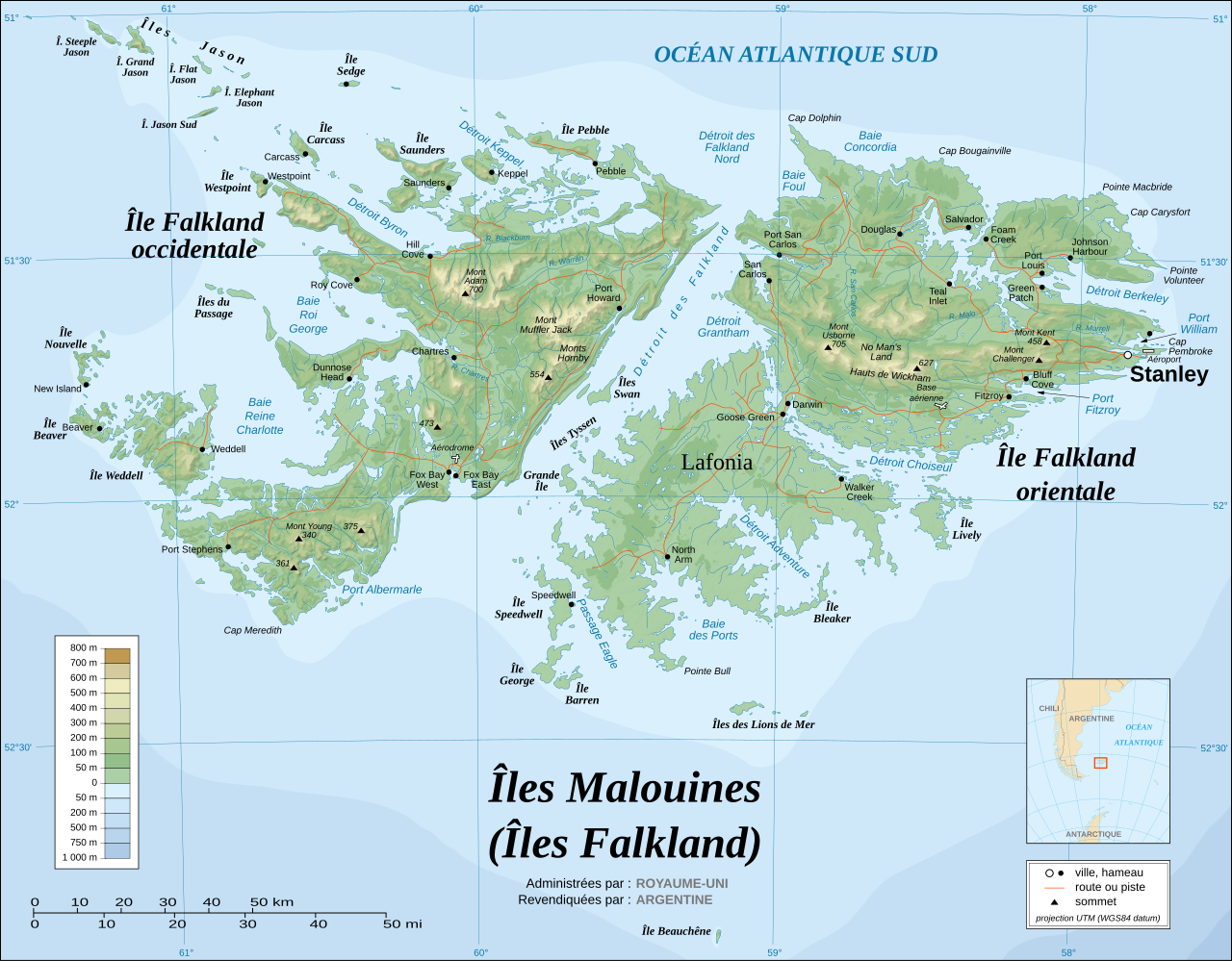
English: Topographic map of the Falkland Islands (in French). The Falkland Islands are an archipelago in the South Atlantic Ocean, located 300 miles off the coast of Argentina. They consist of two main islands, East Falkland and West Falkland, together with about 700 smaller islands. Stanley, on East Falkland, is the capital and largest city. The islands are a self-governing Overseas Territory of the United Kingdom.
Français : Carte topographique des Îles Malouines. Les Malouines forment un archipel dans l'Océan Atlantique Sud à 480 km des côtes argentines. Il est composé de deux îles principales, East Falkland et West Falkland, et de 700 autres îles et îlots. Stanley, sur East Falkland, est la capitale et la plus grande agglomération de l'archipel. Les Malouines sont un territoire autonome du Royaume-Uni. |
||
| گات | November 2007 using elements from the original version of April 2007 | ||
| سرچشمٱ |
Own work ; Topographic map : NASA Shuttle Radar Topography Mission (SRTM3 v.2) (public domain) edited with dlgv32 Pro/Global Mapper and vectorized with Inkscape ; UTM projection ; WGS84 datum ; shaded relief (composite image of N-W, W and N lightning positions) ; Approximate scale of topographic data and shore / lakes limits : 1:705,000 ; of the bathymetry : 1:3.720.000 Bathymetry : USGov public domain data provided by the Demis add-on for World Wind (see the approval e-mail) ; Other references used for additional data : * UK government map ; * NASA World Wind ; * CIA map available on the site of the University of Texas at Austin ; * Microsoft Encarta atlas (1999 edition). Note : The shaded relief is a raster image embedded in the SVG file which increases its size. If you want a lighter map for other purposes, delete the shaded relief image in your file. |
||
| نڤیسیار | Eric Gaba (Sting - fr:Sting) | ||
| دٱسرسی (د نۊ ڤ کار گرتن اؽ جانؽا) |
|
||
| دیگر نسخهها |
[]
|


.svg)


.svg)


|
This SVG file contains embedded text that can be translated into your language, using any capable SVG editor, text editor or the SVG Translate tool. For more information see: About translating SVG files. |
د هال ۉ بار لیسانس دار بیئن
من، صاحب حقوق قانونی این اثر، به این وسیله این اثر را تحث اجازهنامههای ذیل منتشر میکنم:

|
اْجازٱڤرداشتن، درتیچ کاری ۉ/یا آلشت داٛئن سی سنٱد زؽر نخیز شٱرایت موجٱڤز موستٱنٱدؽا آزاد گنو، نۏسخٱ ۱٫۲ یا هٱر نۏسخٱ نهایی کاْ ڤ دٱس بونیاد نٱرم ٱفزار آزاد درتیچ کار بیٱ; بؽ بیئن بٱئرجایا ایستا (بؽ آلشت)، نیسسٱیا ری جلد، ۉ نیسسٱیا دما جلد، ڤ تو داٛئٱ مۊئٱ. یاٛ ڤرداشت د موجٱڤز د یاٛ بٱئرجا ڤا داسوݩ موجٱڤز موستٱنٱدؽا آزاد گنو دما دیس کاری بیٱ. |
| اؽ جانؽا زؽرنٱخیز لیسانس Creative Commons Attribution-Share Alike 3.0 Unported ٱ . | ||
| ||
| این برچسب مجوز بهعنوان بخشی از روزآمدسازی مجوز GFDL، به این پرونده افزوده شد. |
این پرونده با اجازهنامهٔ کریتیو کامانز Attribution-Share Alike 2.5 عمومی، 2.0 عمومی و 1.0 عمومی منتشر شده است.
- شما آزادؽت:
- سی بٱئرکنوݩ – سی ڤرداشتن، درتیچ کردن ۉ داٛین سی کار
- د نۊ د یٱک شؽڤسن – سی هومدٱنڳی ڤا کار
- زؽر نخیز شٱرتؽا هاری:
- کاریاری کردن – شما بایٱد آرنڳ ناْ جۊرؽ کاْ ڤ دٱس نڤیسکاریا موجٱڤز دٱ موشٱخٱس بیٱ، نسبٱت کاری بٱکؽت(ڤلی نٱ جۊرؽ کاْ ڤانمۊد بۊئٱ کاْ ڤنو شما یا ڤ کار گرتن شما ناْ د آرنڳ پر ۉ پیم کاری کردنٱ).
- بٱئرکنوݩ چی – ٱر شما اؽ کار ناْ ٱنجوم باٛئؽت یا آلشتش بٱکؽت یا ڤٱناْ جا ڤ جا بٱکؽت شایٱت یٱ باعس بۊئٱ کاْ نٱتیجٱ کار شما زؽر نخیز یاٛ لیسانس هنی یا چی دماییا درتیچ با.
شما سی اؽ گوزنیشتو باس یاٛ لیسانس اْنتخاب بٱکؽت.
ڤیرگار جانؽا
ری ڤيرگارؽا بٱپۊرنؽت تا نۏسخٱ مٱربۊتاْ باٛینؽت.
| ڤيرگار/ڤٱخت | عٱسگ کوچک بیٱ | اۊیٱکؽا | کاریار | ڤیر ۉ باڤٱر | |
|---|---|---|---|---|---|
| تازٱ با | ۱۶ نوڤامر ۲۰۰۷، ساعت ۱۸:۴۹ | | ۲٬۵۵۰ در ۱٬۹۹۰ (۱٫۹۳ مگابایت) | Sting | New background ; some names correction / addition ; - 1982 CIA census data |
| ۵ آڤریل ۲۰۰۷، ساعت ۱۹:۱۳ |  | ۲٬۵۵۰ در ۱٬۹۹۰ (۲٫۰۳ مگابایت) | Sting | Enhanced shaded relief | |
| ۵ آڤریل ۲۰۰۷، ساعت ۰۵:۰۹ |  | ۲٬۵۵۰ در ۱٬۹۹۰ (۱٫۸۶ مگابایت) | Sting | {{Information |Description={{en}}The '''Falkland Islands''' are an archipelago in the South Atlantic Ocean, located 300 miles off the coast of Argentina. They consist of two main islands, East Falkland and West Falkland, together with about 700 smalle |
ڤ کار گرتن جانؽا
ایچاْ هیچ بٱلگاٛیی سی هوم پیاٛڤٱن بیئن ڤا اؽ جانؽا نؽ